Subject: WALNEY EXTENSION (WOWO4) – COMMISIONING OF SUB-STATION Z04
Dear All, 93/17
On or around Monday 4th December, and depending on weather and conditions, the Jack-up vessel ‘SEAJACKS SCYLLA’ is scheduled to jack-up at the Offshore Sub-Station Z04 in the section of the WALNEY EXTENSION defined as WOWO4.
‘SEAJACKS SCYLLA’ will be supporting commissioning works and although this work is not expected to interfere with any other vessel and as there will be a considerable amount of activity with numerous other vessels involved a wide berth is requested from any passing vessel during the time that ‘SEAJACKS SCYLLA’ can be observed on site.
Attached for information is a small chartlet that shows the layout of the WALNEY EXTENSION (WOWO3+4) WIND FARM with both sections WOWO3 and WOWO4 as well as the two Sub-Stations Z03 and Z04 clearly marked, there is also a picture of ‘SEAJACKS SCYLLA’
………………………………………………………….
The primary Wind Farm Site guard vessel ‘KARIMA’ will be on site and can be contacted for any information regarding vessel movements, a listening watch will be kept on VHF Channels 16 & 12.
’KARIMA’ will conduct 6 hourly Securite broadcasts informing Mariners of site relevant safety information, these will be announced on VHF Channel 16 and broadcast will take place on VHF channel 67 at 06:00, 12:00, 18:00 & 00:00.
Please note that the chartlet is provided for information purposes only and should not be used for navigation.
Please do not hesitate to contact me if you are unsure about any of the above or require any further information, also please pass this information to any of your colleagues who you think might be interested.
If you know of any fisherman who works the area and does not receive this information or anybody else who would benefit from this information please let me know.
Regards : Tom Watson
Tel………. Mobile 07903 173 624
Home 01253 875565
Richard Hoad
Dec042017
KEY Notice, Warning of the Bigger ‘Extension to Walney’
KEY Notice, it warns of the bigger ‘Extension to Walney’ & constant traffic.
Mike
From: Tom Watson
Sent: Friday, December 01, 2017 4:18 PM
Subject: WALNEY EXTENSION (WOWO3+4) – CONSTRUCTION – INSTALLATION VESSELS – CABLE LAY VESSELS FOR INFIELD AND INTERLINK CABLES
Dear All, 092/17
WALNEY EXTENSION (WOWO3+4) – CONSTRUCTION
BOTH SECTIONS OF THE WALNEY EXTENSION (WOWO3+4) REMAIN A DESIGNATED CONSTRUCTION AREA
CARDINAL AND SPECIAL MARKER BUOYS ARE MARKING BOTH AREAS
Please note that the whole of this area remains a designated construction site and all mariners are requested and advised to mark the positions of these Buoys on their charts/plotters and unless there are matters relating to their own safety or the safety of others they should keep clear and not enter the buoyed area until the Wind Farm has been commissioned with the Buoys removed and you have been informed.
Please refer to attachment Page 1
All mariners should also note that there will be a constant stream of traffic between the Wind Farm Site, Belfast, Barrow and Heysham.
…………………………………………………………………………….
CONSTRUCTION AND INSTALLATION PROGRESS
SUB-STATIONS
Both Offshore Sub-Station Z03 (section WOWO3) and Z04 (section WOWO4) have been installed
ZO3 (section WOWO3)
The accommodation Jack-up ‘SEA FOX 2’ is jacked-up close to this Sub-Station while commissioning work is ongoing.
ZO4 (section WOWO4)
On or around Monday 4th December, and depending on weather and conditions, the Jack-up vessel ‘SEAJACKS SCYLLA’ is scheduled to jack-up at this Sub-Station to support commissioning works.
……………………………………………………………………………….
Section WOWO3
All 40 of the Wind Turbine Generators in this section of the Wind Farm are installed, 6 WTGs have now been commissioned and are producing power to the National Grid : A03, E01, E02, E03, F03, G02.
Work on commissioning in this section will continue as weather and conditions permit.
Section WOWO4
All of the Mono-piles complete with the Transition Piece are now installed in this section of the Wind Farm.
INSTALLATION VESSELS ON SITE
There are no Turbine installation vessels on site at this time
Various support and Anchor Handling Tugs (AHTs) are on site to assist in manoeuvring and installation CTVs will also be operating between the area of the Wind Farm site and Barrow.
A 500 minimum meter Safety Exclusion Distance is requested around all of the construction vessel at all times while on site
Pictures of the Installation vessels as well as some of the Anchor Handling and Transport Tugs that can be expected on site and in the area are on page 2 of the attachment.
………………………………………………………………………
CABLE LAY/CABLE BURIEL/ROCK PLACEMENT VESSELS
The 15 meter Cable Trenching vessel ‘HERMES 1V’ (picture attached) is scheduled to carry out trenching operations at a section of the WOWO4 Export Cable in the Lune Deep/Heysham Lake area (off Middleton Sands) as soon as weather and conditions permit. The section is identified as being shaded green on the attached chartlet.
The Rock Placement vessel ‘ROCK PIPER’ is on site to carry out cable protection by rock placement at specified sections of the Inter-Array/Inter-Link Cables.
If required the site Guard Vessel ‘KARIMA’ can be contacted on VHF Channels 16 & 12 for information relating to any Cable Lay, Cable Pull In, Turbine Installation or vessel movement.
‘OCTOPUS’, ‘MARY ANN’ and ‘BENAIAH’ along the Export Cable Route.
(Attachment pages 3 & 4)
’KARIMA’ will conduct 6 hourly Securite broadcasts informing Mariners of site relevant safety information, these will be announced on VHF Channel 16 and broadcast will take place on VHF channel 67 at 06:00, 12:00, 18:00 & 00:00.
…………………………………………………………………………………….
Please note that the chartlets are for provided for information purposes only and should not be used for navigation.
Please do not hesitate to contact me if you are unsure about any of the above or require any further information, also please pass this information to any of your colleagues who you think might be interested.
If you know of any fisherman who works the area and does not receive this information or anybody else who would benefit from this information please let me know.
Detailed below is advance notification of activities which may be noticed in your neighbourhood. All of the limitations and stipulations outlined below apply.
Date
Reason for Notification
04 to 08 Dec
No Firing
11 Dec
Firing
12 to 15 Dec
No Firing
18 to 20 Dec
Firing
21 to 22 Dec
No Firing
25 to 29 Dec
No Firing
I hope that you find this information useful. Please feel free to pass it on to your neighbours.
Yours faithfully,
Penny
Richard Hoad
Nov292017
WALNEY EXTENSION (WOWO4) – COMMISIONING OF SUB-STATION Z04
Subject: WALNEY EXTENSION (WOWO4) – COMMISIONING OF SUB-STATION Z04
Dear All, 93/17
On or around Monday 4th December, and depending on weather and conditions, the Jack-up vessel ‘SEAJACKS SCYLLA’ is scheduled to jack-up at the Offshore Sub-Station Z04 in the section of the WALNEY EXTENSION defined as WOWO4.
‘SEAJACKS SCYLLA’ will be supporting commissioning works and although this work is not expected to interfere with any other vessel and as there will be a considerable amount of activity with numerous other vessels involved a wide berth is requested from any passing vessel during the time that ‘SEAJACKS SCYLLA’ can be observed on site.
Attached for information is a small chartlet that shows the layout of the WALNEY EXTENSION (WOWO3+4) WIND FARM with both sections WOWO3 and WOWO4 as well as the two Sub-Stations Z03 and Z04 clearly marked, there is also a picture of ‘SEAJACKS SCYLLA’
………………………………………………………….
The primary Wind Farm Site guard vessel ‘KARIMA’ will be on site and can be contacted for any information regarding vessel movements, a listening watch will be kept on VHF Channels 16 & 12.
’KARIMA’ will conduct 6 hourly Securite broadcasts informing Mariners of site relevant safety information, these will be announced on VHF Channel 16 and broadcast will take place on VHF channel 67 at 06:00, 12:00, 18:00 & 00:00.
Please note that the chartlet is provided for information purposes only and should not be used for navigation.
Please do not hesitate to contact me if you are unsure about any of the above or require any further information, also please pass this information to any of your colleagues who you think might be interested.
If you know of any fisherman who works the area and does not receive this information or anybody else who would benefit from this information please let me know.
PREESALL UNDERGROUND GAS STORAGE FACILITY (brine discharge pipeline) – NOTICE OF SURVEYS WEST OF ROSSAL POINT – BENTHIC – UXO – GEOTECHNICAL – ARCHAEOLOGICAL
Dear All,
Attached for information is a Notice to Mariners issued by NIRAS concerning three surveys that are scheduled to be carried out offFylde Peninsula in the area to the west of Rossall.
Dependant on weather and conditions survey operations are expected to start on or around Monday 20th November and run until early December and will consist of Benthic, UXO, and Geotechnical/Archaeological surveys.
BENTHIC SURVEY (APPROX 7 DAYS)
The first survey which is expected to start on or around Monday 20th November will involve drop down camera, trawl and grab samplings and will be carried out by the 12 meter NIRAS survey vessel ‘AQUADYNAMIC’.
UXO – MAGNETOMETER SURVEY (APPROX 3 DAYS)
This survey will involve sidescan sonar and multibeam echo sounder and will be carried out by the 8.9 meter BIBBY HYDROMAP vessel ‘EAGLE’
This survey will involve 11 cone penetration tests, 9 vibrocores for archaeological purposed as well as 4 vibrocores for geotechnical purposes and will be carried out by the 26 meter FUGRO catamaran ‘VOE JARL’.
All mariners please note that during survey operations all of the survey vessels will have limited manoeuvrability and a wide berth is requested whenever any of these vessels can be observed on site.
Survey operations will be carried on a 12 hr basis, daylight hours only, and the vessels will be based at Fleetwood for the duration of the works. The attachment has pictures of all of the vessels involved as well as a small chartlet which shows the area of the survey operations
Please do not hesitate to contact me if you require any further information
MOD Eskmeals – Activity Alert: 14th November to 1st December 2017
Detailed below is advance notification of activities which may be noticed in your neighbourhood. All of the limitations and stipulations outlined below apply.
Date
Reason for Notification
14 to 15 Nov
No Firing
16 Nov
Firing
17 Nov
No Firing
20 to 25 Nov
Firing
28 Nov to 01 Dec
Firing
I hope that you find this information useful. Please feel free to pass it on to your neighbours.
Yours faithfully,
Penny
Limitations and Stipulations
All activity on the site is conducted in a strictly controlled environment and presents no danger to the public. Please note that the weather, tide times and other operational requirements play a crucial part in trials planning and scheduling. Any one, or a combination of these factors, may mean that the activity has to be cancelled and rescheduled at short notice and it may not be possible to provide you with an updated schedule of work.
The flying of red flags at the range boundary, or the lima flag (yellow and black quartered) at further points, indicates to members of the public that the range is active and there will be firing activities taking place. At those times the byelaws noted on the signs near to the flags are in force. If the red (or lima) flags are not flying, the range is not active and there will be no firing activities undertaken and as such the byelaws are not in force.
Please be aware that QinetiQ carries out work at MOD Eskmeals on behalf of the MOD, under contract with the Secretary of State for Defence. Because of the nature of the work, QinetiQ is limited as to the level and detail of information it can provide in these communications.
QinetiQ operates a free phone care line number, 0800 0150536 for members of the public to call with any queries or concerns.
Please feel free to forward this message on to others who you feel may benefit.
If you do not wish to receive these notifications please reply to this email with a request to unsubscribe.
Yours sincerely
“This information has been generated for the purposes of informing the public as to QinetiQ’s scheduled operations at the MOD Eskmeals Range and it is acknowledged that the information may be included in other websites and publications. Please note that QinetiQ does not accept responsibility for or endorse any independent website or publication which features this information.”
Penny Haworth Community Liaison Officer, ESKMEALS RANGE
Tel: 0800 0150536
email: Eskmealsenquiries@qinetiq.com http://www.QinetiQ.com QinetiQ – Delivering customer-focused solutions
Please consider the environment before printing this email
Richard Hoad
Sep072017
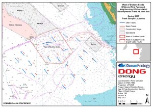
WEST of DUDDON SANDS WIND FARM – Fish Survey Update
Subject: WEST of DUDDON SANDS WIND FARM – FISH SURVEY
Dear All,
‘BENAIAH IV’ (picture attached) has completed the Benthic Survey at the BURBO 2 (EXT) WIND FARM and is now arriving on site at the WEST of DUDDON SANDS WIND FARM to start the Fish Survey
WEST of DUDDON SANDS WIND FARM – FISH SURVEY
This survey consists of 23 Otter Trawls and 23 Beam Trawls (using the 2m Beam) and will last for approx. 5 days, again depending on weather and conditions.
The attached small chartlet gives an overview of the survey with the trawl survey positions in red and the beam trawl survey positions blue.
This survey is not expected to interfere with any other vessel
A listening watch will be kept on VHF Channels 16 & 12 as well as monitoring VHF Channel 14 and ‘BENAIAH IV’ can be contacted for information relating to vessel movement only
…………………………………………………………………………
FISHING INSIDE THE WIND FARM
For more information on the boundaries of the 50 metre Advisory Safety distances please ensure that you have the latest KIS-ORCA information installed – this can be downloaded from http://www.KIS-ORCA.eu
If fishing inside the Wind Farm you are advised to use Dhan Buoys anchored towards the middle of the lane with a long weighted feed line rather than Marker Buoys that can be moved by the strong tides and so foul the Turbines.
………………………………………………………………………..
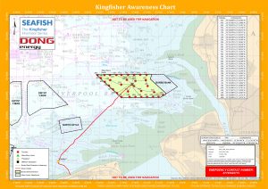
Attached for information is the ‘Kingfisher Flyer’ which gives all of the relevant information concerning WEST of DUDDON SANDS WIND FARM as well as the picture of ‘BENAIAH’.
Please note that the ‘Flyers’ are for provided for information purposes relating to the Wind Farm only and should not be used for navigation.
If you know of any fisherman who works the area and does not receive this information or anybody else who would benefit from this information please let me know.
Please do not hesitate to contact me if you require any further information
This survey is now scheduled to start on Thursday 31st August and will be carried out, as advertised, by the fishing/survey boat ‘BENAIAH IV’ (picture attached) and can be expected to last for approx. 5 to 7 days, depending on weather and conditions.
During this survey ‘BENAIAH IV’ will be using drop down video camera and grab samples and although the survey should not interfere with any other vessel ‘BENAIAH 1V’ will be limited in its ability to manoeuvre whilst sampling, therefore a wide berth, 500 meters, is requested whenever the vessel is on site and passing vessel are requested to reduce speed if possible and keep clear.
A listening watch will be kept on VHF Channels 16 & 14 as well as monitoring VHF Channel 12 for Mersey VTS and ‘BENAIAH IV’ can be contacted for information relating to vessel movement only
…………………………………………………………………
WEST of DUDDON SANDS WIND FARM – FISH SURVEY
Once completed at BURBO 2 (EXT) ‘BENAIAH IV’ will transit across to the WEST of DUDDON SANDS WIND FARM to carry out a Fish survey there.
This survey will consist of 23 Otter Trawls and 23 Beam Trawls (using the 2m Beam) and will last for approx. 5 days, again depending on weather and conditions.
Attached with the vessel specs is a small chartlet giving an overview with the trawl survey positions in red and the beam trawl survey positions blue.
A listening watch will be kept on VHF Channels 16 & 12 as well as monitoring VHF Channel 14 and ‘BENAIAH IV’ can be contacted for information relating to vessel movement only
…………………………………………………………………………
FISHING INSIDE THE WIND FARM
For more information on the boundaries of the 50 metre Advisory Safety distances please ensure that you have the latest KIS-ORCA information installed – this can be downloaded from http://www.KIS-ORCA.eu
If fishing inside the Wind Farm you are advised to use Dhan Buoys anchored towards the middle of the lane with a long weighted feed line rather than Marker Buoys that can be moved by the strong tides and so foul the Turbines.
………………………………………………………………………..
Attached for information is the ‘Kingfisher Flyer’ which gives all of the relevant information concerning BURBO 2 (EXT) WIND FARM as well as the picture of ‘BENAIAH’.
Please note that the ‘Flyers’ are for provided for information purposes relating to the Wind Farm only and should not be used for navigation.
If you know of any fisherman who works the area and does not receive this information or anybody else who would benefit from this information please let me know.
Please do not hesitate to contact me if you require any further information
Regards : Tom Watson
Tel………. Mobile 07903 173 624
Home 01253 875565
Richard Hoad
Aug292017
DEPLOYMENT OF TWO ‘FLiDAR BUOYS AND ONE ‘WAVE BUOY’
IN THE AREA JUST OUTSIDE NW CORNER OF THE WEST of DUDDON SANDS WIND FARM
The two FLiDAR BUOYS, each with an associated marker or pendant buoy, and the one WAVE BUOY have now been deployed in the area just outside of the NW corner of the WEST of DUDDON SANDS WIND FARM, opposite the Met Mast and Turbine A01, and will remain in position for a period of approx. two months.
PLEASE MARK THESE POSITIONS ON YOUR CHARTS/PLOTTERS AND KEEP CLEAR
POSITIONS OF FLIDAR BUOYS
FLiDAR 1 : Lat 54° 0′ 3.64″N Long 003° 33′ 36.00″W
FLiDAR 2 : Lat 54° 0′ 10.68″N Long 003° 33′ 37.07″W
(Characteristics of both buoys : Fl (5) Y 20s range 5nm)
Seabed: The mooring system for each floating LIDARs will consist of a U shaped mooring with 2 cast iron sinkers of approx. 4T weights and approx. 80m of mooring chain with various shackles and swivels. Some of the chain will lie on the seabed, the proportion of chain on the seabed will be dependent and drift and tide
Surface: Each buoy will have a surface marker, or Pendant Buoy, denoting the position of the 2nd 4T seabed sinker weight.
POSITIONS OF MARKER OR PENDANT BUOYS
Pendant 1 : Lat 54° 0′ 05.71″N Long 003° 33′ 29.92″W
Pendant 2 : Lat 54° 0′ 14.70″N Long 003° 33′ 35.41″W
(Characteristics of both buoys : Fl (5) Y 20s range 5nm)
…………………………………………………………………………..
POSITION OF WAVE BUOY
Lat 54° 0′ 1.28″N Long 003° 33′ 25.50″W
(Characteristics : Fl (5) Y 20s range 5nm)
Seabed: Mooring: The mooring connection to the buoy is made with a 12mm stainless steel swivel. Ultrahigh molecular weight polyethylene line (UHMWPE) is used for the mooring line and the mooring is anchored to the ground using up to 600kg of heavy chain.
………………………………………………………………………….
The two attachments include chartlets which show in detail the deployment area at the NW corner of the WEST of DUDDON SANDS WIND FARM as well as pictures of the buoys and all of the information relating to their deployment, there are several pages of information on the third attachment.
Also attached for information is the ‘Kingfisher Flyer’ which gives all of the relevant information concerning the WEST of DUDDON SANDS WIND FARM including the Export Cable Routes.
Please note that the ‘Flyers’ are for provided for information purposes relating to the Wind Farm only and should not be used for navigation.
If you know of any fisherman who works the area and does not receive this information or anybody else who would benefit from this information please let me know.
Please do not hesitate to contact me if you require any further information
 Richard Hoad
 Richard Hoad
 ‘BENAIAH 1V’