A depth of burial survey which will cover the whole length of the Export Cable, from the landfall position off Prestatyn and out to the Wind Farm Sub-Station, is scheduled to start on or around Friday 31st March.
This survey will be non-intrusive to the seabed and will be carried out in two stages by two survey vessels.
The survey vessel ‘BIBBY ATHENA’, operating on a 24hr day basis, will conduct a 2 day survey using an ROV with a minimum of 3.5 meters from the seabed, expected 31stMarch until 1st April.
The survey vessel ‘LIA’, operating on a 12 hr day basis, will conduct a 4 day Geophysical Survey using Hull Mounted Multi-Beam Echo Sounding Equipment, expected 1st April until 4th April.
Start dates and length of survey operations are dependent on weather and conditions.
It is not expected that this survey will interfere with any other vessel but a wide berth, minimum 500 meters, is requested around both vessel during survey operations and passing vessels are requested to reduce speed if possible.
Both vessels will keep a listening watch on VHF channel 16 & 14 as well as monitoring VHF Channel 12 for Mersey VTS and can be contacted for information relating to vessel movement only.
Attached for information is a small chartlet which shows the run of the Export Cable from the Landfall at Prestatyn out to the Wind Farm Sub-Station along with a picture of the two survey vessels
Please do not hesitate to contact me if you require any further information.
The Cable Lay vessel ‘MAERSK CONNECTOR’ is now arriving on site to begin laying the first section of the Export Cables.
‘MAERSK CONNECTOR’ will be accompanied at all times by the Tug ‘EN AVANT 20’
Four Anchor Handling (AHV) vessels ‘MORAG M’, ‘LEANNE P’, ‘AILEEN M’, ‘MARILYN M’ as well as the Guard Boat ‘EILEEN MAY’ will also be in attendance during Cable Lay
Pictures of these vessels have already been distributed but if anybody would like any additional copies please contact me.
‘MAERSK CONNECTOR’ can be expected to be on site for a period of approx. three weeks before returning to Sweden to re-load.
Fishermen are requested/advised to make sure that there is no gear within the Export Cable corridor as advertised in previous correspondence, if in any doubt please contact me.
A wide berth, minimum 500 meters, is requested and required around all of the vessels engaged in the Cable Lay.
The Guard Vessel ‘EILEEN MAY’ will keep a listening watch on VHF Channels 16 & 12 and can be contacted for information relating to vessel movements only.
Please do not hesitate to contact me if you are unsure about any of the above or require any further information, also please pass this information to any of your colleagues who you think might be interested.
This information is also being posted to all of the fishermen and professional anglers that I have home addresses for,If you know of any fisherman or professional angler who works the area and does not receive this information or anybody else who would benefit from this information please let me know.
MOD Eskmeals – Activity Alert: 6thMarch to 17thMarch 2017
Dear Resident,
Detailed below is advance notification of activities which may be noticed in your neighbourhood. All of the limitations and stipulations outlined below apply.
Date
Reason for Notification
06 Mar to 10 Mar
Firing
13 Mar to 17 Mar
Firing
I hope that you find this information useful. Please feel free to pass it on to your neighbours.
Yours faithfully,
Penny
Limitations and Stipulations
All activity on the site is conducted in a strictly controlled environment and presents no danger to the public. Please note that the weather, tide times and other operational requirements play a crucial part in trials planning and scheduling. Any one, or a combination of these factors, may mean that the activity has to be cancelled and rescheduled at short notice and it may not be possible to provide you with an updated schedule of work.
The flying of red flags at the range boundary, or the lima flag (yellow and black quartered) at further points, indicates to members of the public that the range is active and there will be firing activities taking place. At those times the byelaws noted on the signs near to the flags are in force. If the red (or lima) flags are not flying, the range is not active and there will be no firing activities undertaken and as such the byelaws are not in force.
Please be aware that QinetiQ carries out work at MOD Eskmeals on behalf of the MOD, under contract with the Secretary of State for Defence. Because of the nature of the work, QinetiQ is limited as to the level and detail of information it can provide in these communications.
QinetiQ operates a free phone care line number, 0800 0150536 for members of the public to call with any queries or concerns.
Please feel free to forward this message on to others who you feel may benefit.
If you do not wish to receive these notifications please reply to this email with a request to unsubscribe.
Yours sincerely
“This information has been generated for the purposes of informing the public as to QinetiQ’s scheduled operations at the MOD Eskmeals Range and it is acknowledged that the information may be included in other websites and publications. Please note that QinetiQ does not accept responsibility for or endorse any independent website or publication which features this information.”
A series of CARDINAL and SPECIAL MARKER BUOYS are now marking the site of the WALNEY EXTENSION (WOWO3+4) WIND FARM SITE.
As this area is now designated as a construction site all mariners are requested and advised to mark the positions of these Buoys on their charts/plotters and unless there are matters relating to their own safety or the safety of others they should keep clear and not enter the buoyed area until the Wind Farm has been commissioned with the Buoys removed and you have been informed.
On the attachment the first small chartlet shows the Wind Farm Layout with the buoy positions around the perimeter as well as the small graph which gives all of the information relating to the Cardinal and Special Marker Buoys.
The second small chartlet on the attachment shows the positions of the 4 WAVE RIDER BUOYS, No’s 3 & 4 are inside the perimeter of the Wind Farm and have been installed, No’s 1 & 2 are at positions along the Export Cable Route, in the Lune and Heysham Lake area, and are scheduled to be installed on Tuesday 7th Feb as long as weather and conditions permit.
…………………………………………………………………………………………………………..
WAVE RIDER BUOYS
Two Wave Rider Buoys have been deployed within the site of the proposed WALNEY (EXTENSION) WIND FARM (WOWO3+4).
Wave Rider Buoy 3 (WB-3) position: Lat 54° 05.60’N Long 003° 44.40’W (see attached chartlet)
Wave Rider Buoy 4 (WB-4) position: Lat 54° 06.57’N Long 003° 53.26’W (see attached chartlet)
Both Buoys characteristics: FI (5) Y 20s range 5nm
……………………………………………………………………………………
Please note that the two Wave Rider Buoys that are to be stationed at positions along the Export Cable Route are subject to a change of location to that first advertised, they are scheduled to be deployed on Tuesday 7th Feb.
Wave Rider Buoy 1 (WB-1) position: Lat 53° 59.20’N Long 003° 1.37’W (see attached chartlet)
Wave Rider Buoy 2 (WB-2) position: Lat 53° 54.24’N Long 003° 19.00’W (see attached chartlet)
Both Buoys characteristics: FI (5) Y 20s range 5nm
PLEASE MARK THESE POSITIONS ON YOUR CHART/PLOTTER AND KEEP CLEAR
………………………………………………………………..
WIND FARM GUARD VESSEL
The Guard Vessel ‘KARIMA’(picture attached) will be on stationshortly and will conduct 6 hourly Securite broadcasts informing Mariners of site relevant safety information, these will be announced on VHF Channel 16 and broadcast will take place on VHF channel 67 at 06:00, 12:00, 18:00 & 00:00.
……………………………………………………….
Please pass this information to any of your colleagues who you think might find it useful, also if you know of any fisherman who works the area and does not receive this information or anybody else who would benefit from this information please let me know.
Please do not hesitate to contact me if you require any further information.
PREPARATIONS FOR CONSTRUCTION– WALNEY EXTENSION (WOWO3+4)
INFIELD (INTER-ARRAY) AND EXPORT CABLE – PRE-LAY GRAPNEL RUN
As part of the preparations for construction a pre-lay grapnel run along the INFIELD or INTER-ARRAY CABLE ROUTES within both sections of the Wind Farm as well as along the whole length of the TWO EXPORT CABLE ROUTES is scheduled to begin in early February at a date to be confirmed.
The grapnel run will be carried out by the 27.7m Briggs Marine Multi-Cat Work Boat ‘FORTH WARRIOR’ (picture attached) and depending on weather and conditions as well as the requirement for any boulder or debris removal can be expected to last several weeks.
During Pre-Lay Grapnel operations ‘FORTH WARRIOR’ will keep a listening watch on VHF Channels 16 and 12 and can be contacted for information relating to vessel movement only.
The first attachment has two small chartlets, one gives information concerning the boundary of the Wind Farm site while the other shows the Turbine layout, there is also a picture of ‘FORTH WARRIOR’.
The second attachment shows the corridor of the EXPORT CABLE ROUTES down which ‘FORTH WARRIOR’ will operate.
Please note that the chartlets are for provided for information purposes only and should not be used for navigation.
If you know of any fisherman who works the area and does not receive this information or anybody else who would benefit from this information please let me know.
Please do not hesitate to contact me if you require any further information
The latest survey has identified two areas where there is potential EXPOSED/FREE-SPAN CABLE along the EXPORT CABLES of the WEST of DUDDON SANDS OFFSHORE WIND FARM
There is the potential that both cables are exposed in the area immediately to either side, to the East and West, of the BARROW WIND FARM EXPORT CABLE CROSSING
POTENTIAL FREE-SPANS / EXPOSURES EAST OF BARROW CABLE CROSSING
The two expanses of potential exposure have been identified between the following co-ordinates:
PLEASE MARK THESE POSITIONS ON YOUR CHART/PLOTTER AND KEEP CLEAR
POSITION OF CABLE CROSSING
Lat 54 00.3 Long 002 57.9
………………………………………………………………………..
Attached for information is the ‘Kingfisher Flyer’ which gives all of the relevant information concerning the WEST of DUDDON SANDS WIND FARM, including the Export Cable Routes.
Please note that the ‘Flyers’ are for provided for information purposes relating to the Wind Farm only and should not be used for navigation
Please do not hesitate to contact me if you are unsure about any of the above or require any further information, also please pass this information to any of your colleagues who you think might be interested also if you know of any fisherman who works the area and does not receive this information or anybody else who would benefit from this information please let me know.
More News From the Environment Agency on Dangers to Shipping Duddon Sands
DEPLOYMENT OF TWO ‘FLiDAR BUOYS AND ONE ‘WAVE BUOY’
IN THE AREA JUST OUTSIDE NW CORNER OF THE WEST of DUDDON SANDS WIND FARM
The Bay Towage vessel ‘TORCH’ and the Briggs Marine vessel ‘FORTH WARRIOR’ are now on site at the NW corner of the WEST of DUDDON SANDS WIND FARM installing the two FLiDAR BUOYS, each with an associated marker or pendant buoy, and the one WAVE BUOY (pictures of both vessels attached).
This installation has been delayed due to unsettled weather.
The buoys are being deployed in the area just outside of the NW corner of the WEST of DUDDON SANDS WIND FARM, opposite the Met Mast and Turbine A01 and will remain in position for a period of approx. six months.
PLEASE MARK THESE POSITIONS ON YOUR CHARTS/PLOTTERS AND KEEP CLEAR
POSITIONS OF FLIDAR BUOYS
FLiDAR 1 : Lat 54° 0′ 3.64″N Long 003° 33′ 36.00″W
FLiDAR 2 : Lat 54° 0′ 10.68″N Long 003° 33′ 37.07″W
(Characteristics of both buoys : Fl (5) Y 20s range 5nm)
Seabed: The mooring system for each floating LIDARs will consist of cast iron sinkers of approx. 4T weight and approx. 80m of mooring chain with various shackles and swivels. Some of the chain will lie on the seabed, the proportion of chain on the seabed will be dependent and drift and tide
Surface: Each buoy will have a surface marker, or Pendant Buoy, denoting the position of the 2nd 4T seabed sinker weight.
POSITIONS OF MARKER OR PENDANT BUOYS
Pendant 1 : Lat 54° 0′ 05.71″N Long 003° 33′ 29.92″W
Pendant 2 : Lat 54° 0′ 14.70″N Long 003° 33′ 35.41″W
(Characteristics of both buoys : Fl (5) Y 20s range 5nm)
…………………………………………………………………………..
POSITION OF WAVE BUOY
Lat 54° 0′ 1.28″N Long 003° 33′ 25.50″W
(Characteristics : Fl (5) Y 20s range 5nm)
Seabed: Mooring: The mooring connection to the buoy is made with a 12mm stainless steel swivel. Ultrahigh molecular weight polyethylene line (UHMWPE) is used for the mooring line and the mooring is anchored to the ground using up to 600kg of heavy chain.
………………………………………………………………………….
The two attachments include chartlets which show in detail the deployment area at the NW corner of the WEST of DUDDON SANDS WIND FARM as well as pictures of the buoys and all of the information relating to their deployment, there are several pages of information on the third attachment.
Also attached for information is the ‘Kingfisher Flyer’ which gives all of the relevant information concerning the WEST of DUDDON SANDS WIND FARM including the Export Cable Routes.
Please note that the ‘Flyers’ are for provided for information purposes relating to the Wind Farm only and should not be used for navigation.
If you know of any fisherman who works the area and does not receive this information or anybody else who would benefit from this information please let me know.
Please do not hesitate to contact me if you require any further information
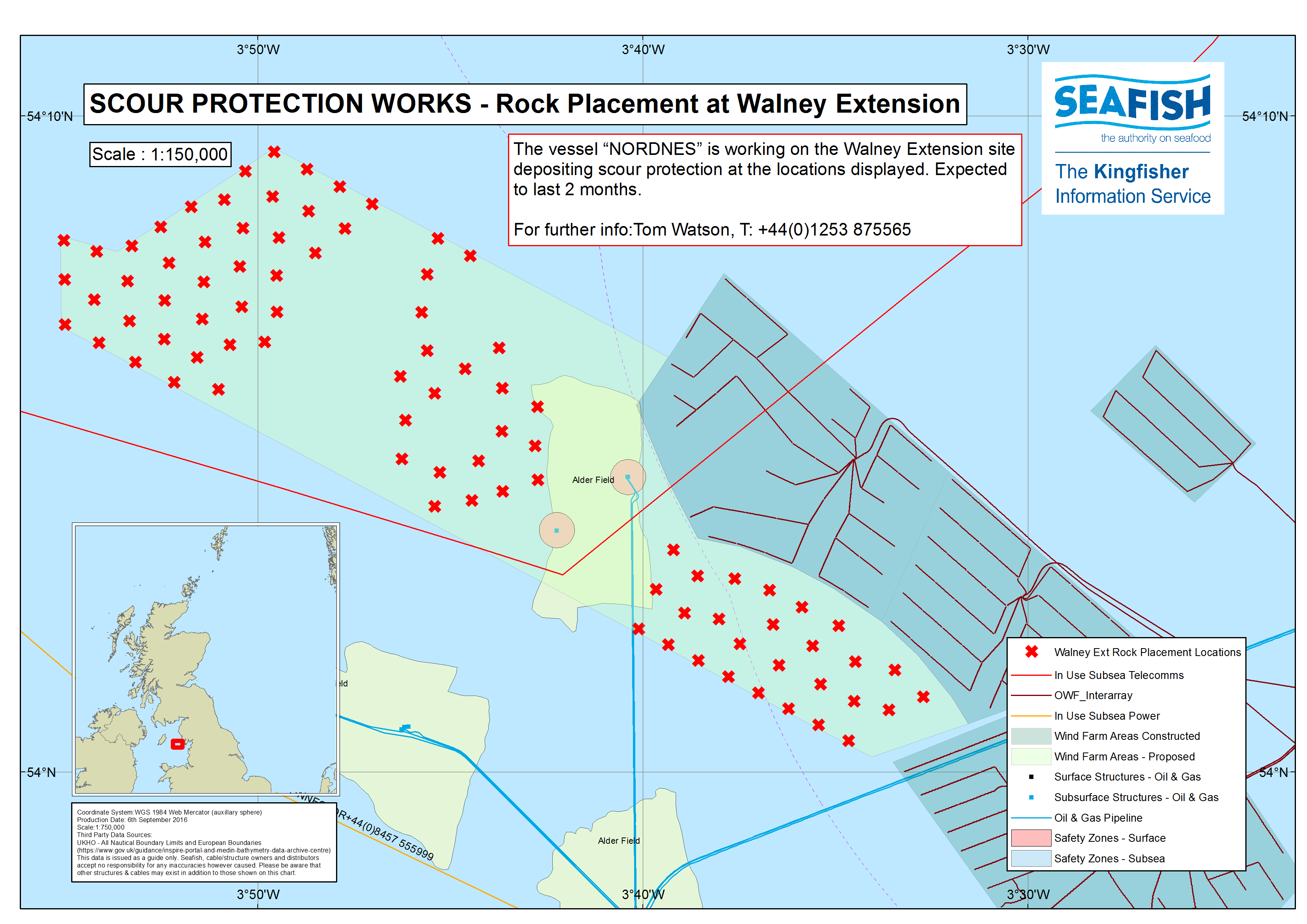
WALNEY OFFSHORE WIND FARM EXTENSION (WOWO3+4) – PREPARATION FOR CONSTRUCTION – ROCK PROTECTION AT CABLE CROSSINGS
Dear All,
002/17
PREPARATION FOR CONSTRUCTION
SCOUR PROTECTION AT TURBINE POSITIONS – ROCK PROTECTION AT CABLE CROSSINGS
SCOUR PROTECTION AT TURBINE POSITIONS
The bulk Carrier/Rock Placement (Fall Pipe) vessel ‘NORDNES’ is on passage back to the site of THE WALNEY EXTENSION (WOWO3+4) WIND FARM, current position South Minch, and can be expected back on site tomorrow to continue depositing scour protection at selected Turbine positions within the proposed Wind Farm site. (see second attachment).

 Richard Hoad
 WOWO3+4 Cable Crossings - 'ROCKPIPER'