This survey is now scheduled to start on Thursday 31st August and will be carried out, as advertised, by the fishing/survey boat ‘BENAIAH IV’ (picture attached) and can be expected to last for approx. 5 to 7 days, depending on weather and conditions.
During this survey ‘BENAIAH IV’ will be using drop down video camera and grab samples and although the survey should not interfere with any other vessel ‘BENAIAH 1V’ will be limited in its ability to manoeuvre whilst sampling, therefore a wide berth, 500 meters, is requested whenever the vessel is on site and passing vessel are requested to reduce speed if possible and keep clear.
A listening watch will be kept on VHF Channels 16 & 14 as well as monitoring VHF Channel 12 for Mersey VTS and ‘BENAIAH IV’ can be contacted for information relating to vessel movement only
…………………………………………………………………
WEST of DUDDON SANDS WIND FARM – FISH SURVEY
Once completed at BURBO 2 (EXT) ‘BENAIAH IV’ will transit across to the WEST of DUDDON SANDS WIND FARM to carry out a Fish survey there.
This survey will consist of 23 Otter Trawls and 23 Beam Trawls (using the 2m Beam) and will last for approx. 5 days, again depending on weather and conditions.
Attached with the vessel specs is a small chartlet giving an overview with the trawl survey positions in red and the beam trawl survey positions blue.
A listening watch will be kept on VHF Channels 16 & 12 as well as monitoring VHF Channel 14 and ‘BENAIAH IV’ can be contacted for information relating to vessel movement only
…………………………………………………………………………
FISHING INSIDE THE WIND FARM
For more information on the boundaries of the 50 metre Advisory Safety distances please ensure that you have the latest KIS-ORCA information installed – this can be downloaded from http://www.KIS-ORCA.eu
If fishing inside the Wind Farm you are advised to use Dhan Buoys anchored towards the middle of the lane with a long weighted feed line rather than Marker Buoys that can be moved by the strong tides and so foul the Turbines.
………………………………………………………………………..
Attached for information is the ‘Kingfisher Flyer’ which gives all of the relevant information concerning BURBO 2 (EXT) WIND FARM as well as the picture of ‘BENAIAH’.
Please note that the ‘Flyers’ are for provided for information purposes relating to the Wind Farm only and should not be used for navigation.
If you know of any fisherman who works the area and does not receive this information or anybody else who would benefit from this information please let me know.
Please do not hesitate to contact me if you require any further information
Regards : Tom Watson
Tel………. Mobile 07903 173 624
Home 01253 875565
Richard Hoad
Aug292017
DEPLOYMENT OF TWO ‘FLiDAR BUOYS AND ONE ‘WAVE BUOY’
IN THE AREA JUST OUTSIDE NW CORNER OF THE WEST of DUDDON SANDS WIND FARM
The two FLiDAR BUOYS, each with an associated marker or pendant buoy, and the one WAVE BUOY have now been deployed in the area just outside of the NW corner of the WEST of DUDDON SANDS WIND FARM, opposite the Met Mast and Turbine A01, and will remain in position for a period of approx. two months.
PLEASE MARK THESE POSITIONS ON YOUR CHARTS/PLOTTERS AND KEEP CLEAR
POSITIONS OF FLIDAR BUOYS
FLiDAR 1 : Lat 54° 0′ 3.64″N Long 003° 33′ 36.00″W
FLiDAR 2 : Lat 54° 0′ 10.68″N Long 003° 33′ 37.07″W
(Characteristics of both buoys : Fl (5) Y 20s range 5nm)
Seabed: The mooring system for each floating LIDARs will consist of a U shaped mooring with 2 cast iron sinkers of approx. 4T weights and approx. 80m of mooring chain with various shackles and swivels. Some of the chain will lie on the seabed, the proportion of chain on the seabed will be dependent and drift and tide
Surface: Each buoy will have a surface marker, or Pendant Buoy, denoting the position of the 2nd 4T seabed sinker weight.
POSITIONS OF MARKER OR PENDANT BUOYS
Pendant 1 : Lat 54° 0′ 05.71″N Long 003° 33′ 29.92″W
Pendant 2 : Lat 54° 0′ 14.70″N Long 003° 33′ 35.41″W
(Characteristics of both buoys : Fl (5) Y 20s range 5nm)
…………………………………………………………………………..
POSITION OF WAVE BUOY
Lat 54° 0′ 1.28″N Long 003° 33′ 25.50″W
(Characteristics : Fl (5) Y 20s range 5nm)
Seabed: Mooring: The mooring connection to the buoy is made with a 12mm stainless steel swivel. Ultrahigh molecular weight polyethylene line (UHMWPE) is used for the mooring line and the mooring is anchored to the ground using up to 600kg of heavy chain.
………………………………………………………………………….
The two attachments include chartlets which show in detail the deployment area at the NW corner of the WEST of DUDDON SANDS WIND FARM as well as pictures of the buoys and all of the information relating to their deployment, there are several pages of information on the third attachment.
Also attached for information is the ‘Kingfisher Flyer’ which gives all of the relevant information concerning the WEST of DUDDON SANDS WIND FARM including the Export Cable Routes.
Please note that the ‘Flyers’ are for provided for information purposes relating to the Wind Farm only and should not be used for navigation.
If you know of any fisherman who works the area and does not receive this information or anybody else who would benefit from this information please let me know.
Please do not hesitate to contact me if you require any further information
As part of the intertidal and nearshore works involving the WALNEY EXTENSION (WOWO3+4) EXPORT CABLE LAY two positions of exposed cable are reported on the Middleton Sands.
These positions will be covered at high water
The positions are reported as between the following co-ordinates :
Lat 54″ 00.34N – Long002″ 56.57W to Lat54″ 00.41W – Long002″ 53.97W
Mariners are requested and advised to note these positions and enter them on their charts/plotters and keep clear until notified that all of the nearshore works have completed and all cables are safely buried.
Please do not hesitate to contact me if you are unsure about any of the above or require any further information, also please pass this information to any of your colleagues who you think might be interested.
If you know of any fisherman who works the area and does not receive this information or anybody else who would benefit from this information please let me know.
Attached is a NtM issued by Transmission Capital concerning Diving Operations that are to be carried out at the Offshore Sub-Station at the ORMONDE OFFSHORE WIND FARM
The DIVE PLATFORM/SUPPORT VESSEL will be ‘YORKSHIRE LADY’ and Dive Operations are expected to start on Thursday 18th May and will last for approx. 7 days, depending weather and conditions.
All work will be carried out in the immediate vicinity of the Sub-Station.
‘YORKSHIRE LADY’ will display the ALPHA FLAG (White and Blue) whenever DIVERS are deployed but a minimum 500 meters Safety Exclusion Zone is requested for this vessel at all times when on site.
During Dive Operations the bow of the vessel will be connected to the ORMONDE Sub-Station (or Offshore Platform) by two Poly-Ethelene/Propylene lines of up to 25 m length, anchors at the stern of the vessel will be deployed at approximately 175 m from the vessel in a NE and SE alignment.
Included with the attached NtM is a small chartlet which shows the location of the works in relation to the Wind Farm as well as a picture of ‘YORKSHIRE LADY’
Also attached for information is the ‘Kingfisher Flyer’ which gives all of the relevant information concerning the ORMONDE OFFSHORE WIND FARM
Please note that the ‘Flyer’ is provided for information relating to the Wind Farm only and should not be used for navigation.
Please do not hesitate to contact me if you require any further information
 Richard Hoad
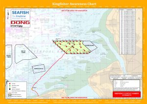 ‘BENAIAH 1V’
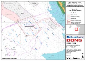
 Richard Hoad