Subject: WALNEY EXTENSION (WOWO4) – COMMISIONING OF SUB-STATION Z04
Dear All, 93/17
On or around Monday 4th December, and depending on weather and conditions, the Jack-up vessel ‘SEAJACKS SCYLLA’ is scheduled to jack-up at the Offshore Sub-Station Z04 in the section of the WALNEY EXTENSION defined as WOWO4.
‘SEAJACKS SCYLLA’ will be supporting commissioning works and although this work is not expected to interfere with any other vessel and as there will be a considerable amount of activity with numerous other vessels involved a wide berth is requested from any passing vessel during the time that ‘SEAJACKS SCYLLA’ can be observed on site.
Attached for information is a small chartlet that shows the layout of the WALNEY EXTENSION (WOWO3+4) WIND FARM with both sections WOWO3 and WOWO4 as well as the two Sub-Stations Z03 and Z04 clearly marked, there is also a picture of ‘SEAJACKS SCYLLA’
………………………………………………………….
The primary Wind Farm Site guard vessel ‘KARIMA’ will be on site and can be contacted for any information regarding vessel movements, a listening watch will be kept on VHF Channels 16 & 12.
’KARIMA’ will conduct 6 hourly Securite broadcasts informing Mariners of site relevant safety information, these will be announced on VHF Channel 16 and broadcast will take place on VHF channel 67 at 06:00, 12:00, 18:00 & 00:00.
Please note that the chartlet is provided for information purposes only and should not be used for navigation.
Please do not hesitate to contact me if you are unsure about any of the above or require any further information, also please pass this information to any of your colleagues who you think might be interested.
If you know of any fisherman who works the area and does not receive this information or anybody else who would benefit from this information please let me know.
Regards : Tom Watson
Tel………. Mobile 07903 173 624
Home 01253 875565
Richard Hoad
Dec042017
KEY Notice, Warning of the Bigger ‘Extension to Walney’
KEY Notice, it warns of the bigger ‘Extension to Walney’ & constant traffic.
Mike
From: Tom Watson
Sent: Friday, December 01, 2017 4:18 PM
Subject: WALNEY EXTENSION (WOWO3+4) – CONSTRUCTION – INSTALLATION VESSELS – CABLE LAY VESSELS FOR INFIELD AND INTERLINK CABLES
Dear All, 092/17
WALNEY EXTENSION (WOWO3+4) – CONSTRUCTION
BOTH SECTIONS OF THE WALNEY EXTENSION (WOWO3+4) REMAIN A DESIGNATED CONSTRUCTION AREA
CARDINAL AND SPECIAL MARKER BUOYS ARE MARKING BOTH AREAS
Please note that the whole of this area remains a designated construction site and all mariners are requested and advised to mark the positions of these Buoys on their charts/plotters and unless there are matters relating to their own safety or the safety of others they should keep clear and not enter the buoyed area until the Wind Farm has been commissioned with the Buoys removed and you have been informed.
Please refer to attachment Page 1
All mariners should also note that there will be a constant stream of traffic between the Wind Farm Site, Belfast, Barrow and Heysham.
…………………………………………………………………………….
CONSTRUCTION AND INSTALLATION PROGRESS
SUB-STATIONS
Both Offshore Sub-Station Z03 (section WOWO3) and Z04 (section WOWO4) have been installed
ZO3 (section WOWO3)
The accommodation Jack-up ‘SEA FOX 2’ is jacked-up close to this Sub-Station while commissioning work is ongoing.
ZO4 (section WOWO4)
On or around Monday 4th December, and depending on weather and conditions, the Jack-up vessel ‘SEAJACKS SCYLLA’ is scheduled to jack-up at this Sub-Station to support commissioning works.
……………………………………………………………………………….
Section WOWO3
All 40 of the Wind Turbine Generators in this section of the Wind Farm are installed, 6 WTGs have now been commissioned and are producing power to the National Grid : A03, E01, E02, E03, F03, G02.
Work on commissioning in this section will continue as weather and conditions permit.
Section WOWO4
All of the Mono-piles complete with the Transition Piece are now installed in this section of the Wind Farm.
INSTALLATION VESSELS ON SITE
There are no Turbine installation vessels on site at this time
Various support and Anchor Handling Tugs (AHTs) are on site to assist in manoeuvring and installation CTVs will also be operating between the area of the Wind Farm site and Barrow.
A 500 minimum meter Safety Exclusion Distance is requested around all of the construction vessel at all times while on site
Pictures of the Installation vessels as well as some of the Anchor Handling and Transport Tugs that can be expected on site and in the area are on page 2 of the attachment.
………………………………………………………………………
CABLE LAY/CABLE BURIEL/ROCK PLACEMENT VESSELS
The 15 meter Cable Trenching vessel ‘HERMES 1V’ (picture attached) is scheduled to carry out trenching operations at a section of the WOWO4 Export Cable in the Lune Deep/Heysham Lake area (off Middleton Sands) as soon as weather and conditions permit. The section is identified as being shaded green on the attached chartlet.
The Rock Placement vessel ‘ROCK PIPER’ is on site to carry out cable protection by rock placement at specified sections of the Inter-Array/Inter-Link Cables.
If required the site Guard Vessel ‘KARIMA’ can be contacted on VHF Channels 16 & 12 for information relating to any Cable Lay, Cable Pull In, Turbine Installation or vessel movement.
‘OCTOPUS’, ‘MARY ANN’ and ‘BENAIAH’ along the Export Cable Route.
(Attachment pages 3 & 4)
’KARIMA’ will conduct 6 hourly Securite broadcasts informing Mariners of site relevant safety information, these will be announced on VHF Channel 16 and broadcast will take place on VHF channel 67 at 06:00, 12:00, 18:00 & 00:00.
…………………………………………………………………………………….
Please note that the chartlets are for provided for information purposes only and should not be used for navigation.
Please do not hesitate to contact me if you are unsure about any of the above or require any further information, also please pass this information to any of your colleagues who you think might be interested.
If you know of any fisherman who works the area and does not receive this information or anybody else who would benefit from this information please let me know.
PREESALL UNDERGROUND GAS STORAGE FACILITY (brine discharge pipeline) – NOTICE OF SURVEYS WEST OF ROSSAL POINT – BENTHIC – UXO – GEOTECHNICAL – ARCHAEOLOGICAL
Dear All,
Attached for information is a Notice to Mariners issued by NIRAS concerning three surveys that are scheduled to be carried out offFylde Peninsula in the area to the west of Rossall.
Dependant on weather and conditions survey operations are expected to start on or around Monday 20th November and run until early December and will consist of Benthic, UXO, and Geotechnical/Archaeological surveys.
BENTHIC SURVEY (APPROX 7 DAYS)
The first survey which is expected to start on or around Monday 20th November will involve drop down camera, trawl and grab samplings and will be carried out by the 12 meter NIRAS survey vessel ‘AQUADYNAMIC’.
UXO – MAGNETOMETER SURVEY (APPROX 3 DAYS)
This survey will involve sidescan sonar and multibeam echo sounder and will be carried out by the 8.9 meter BIBBY HYDROMAP vessel ‘EAGLE’
This survey will involve 11 cone penetration tests, 9 vibrocores for archaeological purposed as well as 4 vibrocores for geotechnical purposes and will be carried out by the 26 meter FUGRO catamaran ‘VOE JARL’.
All mariners please note that during survey operations all of the survey vessels will have limited manoeuvrability and a wide berth is requested whenever any of these vessels can be observed on site.
Survey operations will be carried on a 12 hr basis, daylight hours only, and the vessels will be based at Fleetwood for the duration of the works. The attachment has pictures of all of the vessels involved as well as a small chartlet which shows the area of the survey operations
Please do not hesitate to contact me if you require any further information
Could you please forward details of this excellent cruising initiative.
I know many club members sail both dinghy’s and also have a keen interest with big boat sailing, so here’s a great opportunity for the cruisers !
Dear all,
Just to let you know there is a North Wales and North West Cruising ‘Get together’ on the 2nd December, 3pm, Conwy area, actual location TBC. It’s aimed all those involved in the Cruising Scheme (CI’s, YMI’s, Shorebased Instructors etc), with the possibility of getting out for a sail on 3rd if conditions allow. There will be led discussion on any topics that attendees wish to discuss within a mutually supportive environment. MOB is already on the list… Then an onwards move to eat and drink at a local hostelry! Please contact Cris Miles for more info and to register your interest in attending info@boomsailing.org.uk
THE ANNUAL GENERAL MEETING OF THE RYA NW REGION WILL BE HELD AT
Tower Wood Outdoor Education Centre, Windermere, LA23 3PL
on Saturday 4 November at 1.30pm
Any resolutions for this meeting must be s_ubmitted by email to Peter Hadfield (peter.j.hadfield@gmail.com) the RYA NW Regional Committee’s Hon Secretary by Friday 6 October 2017. If you have any other matter that you wish to raise at this meeting please also let Peter know by this date.
The Agenda will be circulated to Clubs by Saturday 14 October 2017.
Richard Hoad
Sep072017
WEST of DUDDON SANDS WIND FARM – Fish Survey Update
Subject: WEST of DUDDON SANDS WIND FARM – FISH SURVEY
Dear All,
‘BENAIAH IV’ (picture attached) has completed the Benthic Survey at the BURBO 2 (EXT) WIND FARM and is now arriving on site at the WEST of DUDDON SANDS WIND FARM to start the Fish Survey
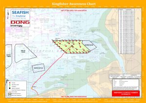
WEST of DUDDON SANDS WIND FARM – FISH SURVEY
This survey consists of 23 Otter Trawls and 23 Beam Trawls (using the 2m Beam) and will last for approx. 5 days, again depending on weather and conditions.
The attached small chartlet gives an overview of the survey with the trawl survey positions in red and the beam trawl survey positions blue.
This survey is not expected to interfere with any other vessel
A listening watch will be kept on VHF Channels 16 & 12 as well as monitoring VHF Channel 14 and ‘BENAIAH IV’ can be contacted for information relating to vessel movement only
…………………………………………………………………………
FISHING INSIDE THE WIND FARM
For more information on the boundaries of the 50 metre Advisory Safety distances please ensure that you have the latest KIS-ORCA information installed – this can be downloaded from http://www.KIS-ORCA.eu
If fishing inside the Wind Farm you are advised to use Dhan Buoys anchored towards the middle of the lane with a long weighted feed line rather than Marker Buoys that can be moved by the strong tides and so foul the Turbines.
………………………………………………………………………..
Attached for information is the ‘Kingfisher Flyer’ which gives all of the relevant information concerning WEST of DUDDON SANDS WIND FARM as well as the picture of ‘BENAIAH’.
Please note that the ‘Flyers’ are for provided for information purposes relating to the Wind Farm only and should not be used for navigation.
If you know of any fisherman who works the area and does not receive this information or anybody else who would benefit from this information please let me know.
Please do not hesitate to contact me if you require any further information
Registered No: 3898088 England Registered Charity No: 1079955
Registered Office: Royal Quays Community Centre, 9 Prince Consort Way, North Shields, NE29 6XB
This survey is now scheduled to start on Thursday 31st August and will be carried out, as advertised, by the fishing/survey boat ‘BENAIAH IV’ (picture attached) and can be expected to last for approx. 5 to 7 days, depending on weather and conditions.
During this survey ‘BENAIAH IV’ will be using drop down video camera and grab samples and although the survey should not interfere with any other vessel ‘BENAIAH 1V’ will be limited in its ability to manoeuvre whilst sampling, therefore a wide berth, 500 meters, is requested whenever the vessel is on site and passing vessel are requested to reduce speed if possible and keep clear.
A listening watch will be kept on VHF Channels 16 & 14 as well as monitoring VHF Channel 12 for Mersey VTS and ‘BENAIAH IV’ can be contacted for information relating to vessel movement only
…………………………………………………………………
WEST of DUDDON SANDS WIND FARM – FISH SURVEY
Once completed at BURBO 2 (EXT) ‘BENAIAH IV’ will transit across to the WEST of DUDDON SANDS WIND FARM to carry out a Fish survey there.
This survey will consist of 23 Otter Trawls and 23 Beam Trawls (using the 2m Beam) and will last for approx. 5 days, again depending on weather and conditions.
Attached with the vessel specs is a small chartlet giving an overview with the trawl survey positions in red and the beam trawl survey positions blue.
A listening watch will be kept on VHF Channels 16 & 12 as well as monitoring VHF Channel 14 and ‘BENAIAH IV’ can be contacted for information relating to vessel movement only
…………………………………………………………………………
FISHING INSIDE THE WIND FARM
For more information on the boundaries of the 50 metre Advisory Safety distances please ensure that you have the latest KIS-ORCA information installed – this can be downloaded from http://www.KIS-ORCA.eu
If fishing inside the Wind Farm you are advised to use Dhan Buoys anchored towards the middle of the lane with a long weighted feed line rather than Marker Buoys that can be moved by the strong tides and so foul the Turbines.
………………………………………………………………………..
Attached for information is the ‘Kingfisher Flyer’ which gives all of the relevant information concerning BURBO 2 (EXT) WIND FARM as well as the picture of ‘BENAIAH’.
Please note that the ‘Flyers’ are for provided for information purposes relating to the Wind Farm only and should not be used for navigation.
If you know of any fisherman who works the area and does not receive this information or anybody else who would benefit from this information please let me know.
Please do not hesitate to contact me if you require any further information
 Richard Hoad
 Richard Hoad
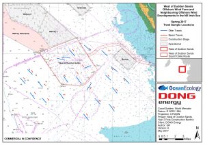
 Richard Hoad
 ‘BENAIAH 1V’